Tuesday, July 6, 2010

AutoCAD Map 2011: "A Practical Guide to AutoCAD Map 3D 2011"


As I mentioned in the previous post, the latest version of "A Practical Guide to AutoCAD Map 3D 2011" is now available. The retail cost is $69.95. I have a few copies at a substantial discount. Please email me at geospatialtech@gmail.com if you are interested.

Monday, June 14, 2010

AutoCAD Map 2011: "A Practical Guide to AutoCAD Map 3D 2011"


The latest version of "A Practical Guide to AutoCAD Map 3D 2011" from DigitalNode is now available.

It's the best book yet written! OK, I stole and revised that line from one of my favorite movies, Amadeus. But it's a fact. I've been training and implementing AutoCAD Map from the very beginning and I've used almost every book out there. This is truly the best designed and informative instructional book I've seen.

The author, Alex Penney, was a member of the original AutoCAD Map 3D product team and was responsible for developing training strategies and training delivery for many releases of AutoCAD Map 3D. Ray Eisenberg, who is a Senior Program Manager at Autodesk brought his instructional design and editorial expertise to the team. I was fortunate to be asked to do the technical editing on the project. It was pleasure working with Alex and Ray, they are true professionals in the industry.

Alex has a special way of taking the most complicated concept and making it understandable. That's not an easy thing to do in a training document.

Each lesson clearly details the concepts and objectives the student will learn as well as great exercises for each topic. The author explains, when needed, why you are performing a certain task during the exercise. This is the first book where I've seen that level of detail and it's extremely helpful to fully understand the task being completed.

I'm looking forward to using "A Practical Guide to AutoCAD Map 3D 2011" again in my next class.

If you would like to purchase a copy you can visit DigitalNode at www.digitalnode.com

Thursday, May 27, 2010

AutoCAD Map 3D 2010: AutoCAD Map 3D 2010 SP2

Autodesk just announced that SP2 is now available. To download this update click HERE......

This update addresses many issues. Here are a few items that have been corrected.

General
  • Cache files are left in the MapCache directory after closing AutoCAD Map 3D without saving the new drawing.
Bulk Copy
  • Bulk copying from a SHP data set to Oracle would sometimes fail to copy numeric fields.

CAD on GIS

  • Checking out a large number of features crashes AutoCAD Map 3D.
  • Attempting to join a linestring to a multi-linestring via the PEDIT command fails.

Classification

  • Some menu items in the “Define Object Classification” dialog box are drawn covered in black.
Import/Export
  • Memory is not reclaimed after running the MAPEXPORTCURRENTMAPTODWG command.
  • Object data does not get exported when running the _MAPEXPORT command from the CLI.
  • EPF files are not honored when running the _MAPEXPORT command from the CLI.
  • The MAPIMPORTFDO and MAPEXPORTFDO commands do not list existing ArcSDE connections.
  • Mapping multiple layers to the same DGN level when exporting to DGN does not function correctly.
Transform/Rubbersheet
  • The ADERSHEET command mishandles MultiLeader and MLine entities.
FDO Raster
  • FDO rasters draw at the wrong location in layout view if the layer coordinate system is different from the map coordinate system.
  • FDO rasters plot at the wrong location if the layer coordinate system is different from the map coordinate system.
  • Adding a bitonal raster image crashes AutoCAD Map 3D.
  • Gaps sometimes display between tiled images.
  • Themed DEMs are not correctly displayed when running AutoCAD Map 3D on non-English operating systems.
  • After connecting to a raster image with a very long file name, clicking on the connection in the Data Connect dialog crashes AutoCAD Map 3D.
  • Zooming in/out after the raster file is renamed crashes AutoCAD Map 3D.

FDO SHP

  • Attributes containing Hebrew, Greek, or Cyrillic characters are not displayed correctly in the Data Table.
  • Under certain conditions, a SHP file can become corrupted when updating the geometry of features.
  • Connecting to a SHP data set containing an invalid SHX index file crashes AutoCAD Map 3D.

Tuesday, March 30, 2010

AutoCAD Map 3D: AutoCAD Map 3D 2011 is now available

The latest version of AutoCAD Map 3D is now available in the Subscription Center as well as a free 30 day trial.

What's new in Map 2011?
  • Integrated Point Cloud tools
  • Grids and Graticules tools - Create and publish maps based on U.S. government military grid reference system (MGRS) standards
  • New & Enhanced Data Support
    • ArcSDE 9.3.1
    • Oracle® 11gR2
    • Microsoft® SQL Server® 2008 SP1
    • PostGIS 1.3.6
    • PostgreSQL 8.3.7-1
    • SQLite 3.6.14
  • Performance Improvements - up to 4 x faster working with FDO data
  • Windows 7 Compatible

Friday, March 26, 2010

AutoCAD 2011 based products: Google Earth Extension now available

The Google Earth Extension is now available for all AutoCAD 2011 based products in both 32 bit and 64 bit versions.

Using the Google Earth Extension‘s simple wizard-driven interface, you can publish your 3D models from AutoCAD directly into the Google Earth application. The technology preview also allows you to import a Google Earth image into AutoCAD, publish your 3D model to Google Earth, drape a Google Earth image onto a 3D mesh in AutoCAD, and attach time span information to your model.

Click here to download the Extension.

Thursday, October 22, 2009

AutoCAD Map 3D 2010: Subscription Advantage Pack

The Subscription Advantage Pack (SAP) is now available for both AutoCAD Map 3D 2010 and Civil 3D 2010.

The SAP for AutoCAD Map 3D 2010 contains valuable new functionality for using and visualizing point clouds that further extends the capabilities of AutoCAD Map 3D 2010 software. This pack also includes 3 new tutorials and Autodesk ImageModeler 2009 software.

The SAP for AutoCAD Civil 3D 2010 contains the functions for AutoCAD Map 3D as well as a Roundabout Layout Tool and about 20 other enhancement tools for Transportation, Survey, and Visualization.

Here is the URL to login to the Subscription Center.

http://subscription.autodesk.com

Thursday, September 24, 2009

AutoCAD Civil 3D 2010: Civil 3D Update 2

AutoCAD Civil 3D 2010 Update 2 is now available.

Click HERE to download the update.

Friday, September 18, 2009

AutoCAD Map 3D 2010: Map 3D Update 1

AutoCAD Map 3D 2010's first update is now available.

Click HERE to download the update.

Wednesday, September 16, 2009

AutoCAD Civil 3D 2010: Missing info in the Subassemblies Tool Palette

You installed Civil 3D 2010 from a deployment from the DVDs. When you start the product, you noticed that the Tool Palette subassemblies were missing.

This is a known issue. To correct the problem, replace the RegisteredTools, Tool Catalogs and ToolPalette subdirectories from a computer where the subassemblies are working.

If you don't have access to a computer where the subassemblies are working properly, follow these instructions.

1. Copy the entire i.e. D:\x86\C3D\CONTENT directory from DVD 2 into the ….AdminImage\x86\C3D directory to overwrite the existing Content folder.

2. Modify the deployment and proceed through the configuration steps to update your deployment.

3. Repair your installation of Civil 3D 2010, using Add or Remove Programs in the Control Panel (Windows). Select the Reinstall option.

4. Start Civil 3D 2010 and confirm that tool palettes have subassemblies.

Tuesday, September 1, 2009

AutoCAD Map 3D 2010 Seminar Series

Wow. What a response to this series. We sold out in just a few days. Thanks to all that have signed up. We will continue this series after the first of the year so if you didn't get into this series we'll get you into the next one....

Monday, August 24, 2009

AutoCAD Map 3D 2010 Seminar Series

Join me for a free informative luncheon seminar series focusing on AutoCAD Map 3D 2010. A variety of topics will be covered with each seminar covering a specific function of this program. Learn to utilize AutoCAD Map 3D 2010 to its full potential.

The seminars will take place the third Friday of every month through the end of the year at the Surveyors Exchange Training Center, located at 3630 Springer St. Sessions are from 12 noon to 1 p.m. and lunch will be provided.

Registration is limited to 20 people per session so register early!

Source Drawings and Queries
Aug. 21, 2009

Creating, Editing, and Classifying Geometry
Sept. 18, 2009

Linking and Managing Drawing Based Attribute Data
Oct. 16, 2009

Importing and Exporting Drawing Based Data
Nov. 20, 2009

Stylizing Drawings - Using the Display Manager
Dec. 18, 2009

Tuesday, August 4, 2009

AutoCAD Civil 3D 2010: Civil 3D Update 1

AutoCAD Civil 3D 2010's first update is now available. It corrects a lot of known issues.

Click HERE to see all the resolved issues in this update.

Click HERE to download the update.

Thursday, July 23, 2009

AutoCAD Map 3D: Google Earth Extension for Map 3D

AutoCAD Map 3D 2010 has a new FDO provider that allows you to publish drawings into Google Earth. But there are times when you need a georeferenced image inside AutoCAD Map 3D to use as an underlay. The Google Earth Extension for Map 3D is a handy application to get this done.

Here is the URL to download and install the Extension:

http://labs.autodesk.com/utilities/google_earth_extension_beta/

Monday, June 22, 2009

MapGuide Maestro: Editor interface for MapGuide Open Source

MapGuide Maestro is an Open Source (LGPL) map authoring tool for MapGuide Open Source.

MapGuide Maestro is a free application that can ease the management of spatial data in MapGuide Open Source. Currently MapGuide Maestro has specialized editor interfaces for editing the following components of MapGuide Open Source: Feature sources, Layer definitions, Map Definitions, Web Layouts and Fusion Layouts.

http://trac.osgeo.org/mapguide/wiki/maestro/Downloads

MapGuide Open Source: MapGuide Open Source 2.1 is now available

MapGuide Open Source is a free web mapping platform that enables users to quickly develop and deploy web mapping applications and geospatial web services. MapGuide features an interactive viewer that includes support for feature selection, property inspection, map tips, and operations such as buffer, select within, and measure. MapGuide includes an XML database for managing content, and supports most popular geospatial file formats, databases, and standards. MapGuide can be deployed on Linux or Windows, supports Apache and IIS web servers, and offers extensive PHP, .NET, Java, and JavaScript APIs for application development. MapGuide Open Source is licensed under the LGPL.

Here is the URL to download MapGuide Open Source.

http://mapguide.osgeo.org/download

In order to take full advatage of MapGuide Open Source, you'll also need to download Maestro. I'll post a blog about Maestro later today......

Friday, June 19, 2009

AutoCAD Map 3D: Fdo2Fdo - Copy and Manage FDO Data Sources

This is a great application. It allows you to copy data from SHP files to SDF, from SHP to Oracle, Oracle to SDF. Basically allows you to copy data from any FDO Data Store to any FDO Data Store.

http://www.sl-king.com/fdo2fdo/download/download.html

Tuesday, June 16, 2009

AutoCAD Map 3D: What is LandXML?

Several companies, including Autodesk, teamed up to create a method for exchanging project information across different software packages, and LandXML is the result. LandXML is a generic, text-based file format used to save project data. It's similar to a DXF™ file, which is a generic file format for vector-based drawing information. LandXML recognizes the following project data:

 Points
 Point groups
 Description keys
 Surfaces
 Parcels
 Horizontal alignments
 Profiles
 Cross sections

LandXML files are always given the extension .xml, and you can view them in any web browser (such as Microsoft Internet Explorer or Netscape Navigator).

LandXML is commonly used to interchange Survey and Civil Engineering data. You can use a LandXML file:

 To transfer information between different Autodesk products such
as Land Desktop, Civil 3D, and Now AutoCAD Map 3D.
 To move or rotate sets of points, surfaces, or alignments.
 To convert data between metric and imperial projects.
 With style sheets to export LandXML data and create customized reports

Note: AutoCAD Map 3D 2010 only supports points information at this time. Surfaces are currently not supported but may be supported in the future.

Thursday, June 11, 2009

AutoCAD Map 3D: Connect to an ArcSDE Provider using FDO

Several of the classes I attended online a few weeks ago were delivered by Neal Niemiec. He is a very bright guy and an excellent instructor. I learned a ton from him and I'm sure you will too. Here is his blog. Please visit it when you can.

http://cadngis.blogspot.com/

This simple exercise will walk you through the configuration and setup to connect to a public ArcSDE site (ver 9.2) and bring that data into the AutoCAD Map 3D user environment.

The first thing you have to do is download and install the ArcGIS Explorer (FREE ESRI Viewer). It can be found here.

http://resources.esri.com/arcgisexplorer/index.cfm?fa=download

Once you've installed the application, you'll need to Copy the pe.dll, sde.dll, sg.dll located in the C:\Program Files\ArcGIS Explorer\bin directory to the C:\Program Files\AutoCAD Map 3D 2010\FDO\bin directory.

FDO Provider For ArcSDE EXERCISE

1. Connect to an ArcSDE Provider using FDO by clicking on the Data icon in the display Manager and choosing – ‘Connect to Data’

2. Connect to the UTAH GIS ArcSDE Portal by using the ‘Add ArcSDE Connection’ – information on the login credentials can be found here: http://gis.utah.gov/sgid_connect or following the screen shot below. The User Name and Login are: agrc

NOTE – it might take a considerable amount of time to connect and retrieve data from this server as it is public!


3. Once you have the available layers you will check the AIRPORTS schema and add that to your map.

4. Next, find out how many objects are within the AIRPORTS Layer … (hint) you will need to first select the AIRPORTS layer in the display manager and click on the Data Table Icon

Wednesday, June 10, 2009

AutoCAD Map 3D: Integrating AutoCAD Map 3D with Google Earth

A few weeks ago I attended One Team University presented by Autodesk. All 14 classes were delivered online which made it interesting. Below is one of the classes I took. All content was developed by Autodesk. During the exercise there's some text you have to copy and paste into the provider.xml file. Please email me if you want the dataset and text to complete the exercise.

Here are the files you'll need to configure your system to work with Google Earth:

1. Download FDO2FDO ver 7.6 from SL King website
http://www.sl-king.com/Fdo2Fdo/download/download.html

2. Download the FDO Provider 3.3 for KML from SL King website
http://www.sl-king.com/FdoKML/download/download.html

3. Download Google Earth
http://pack.google.com/intl/en/integrated_eula.html?hl=en&ciint=ci_earth&ci_earth=on&utm_source=en-cdr-earth4&utm_medium=cdr&utm_campaign=en


This exercise will go over the capabilities of FDO third party providers that will enable AutoCAD Map 3D 2010 to work with KML data sources. KML is the data type used to store geometry by Google Earth.

1. Extract the contents of FdoKingKml_FDO_3_3_1_v0_1_2.zip to C:\Program Files\AutoCAD Map 3D 2010\FDO\bin – these 2 dlls (KingKmlProvier.dll / libexpat.dll) will be used to connect to KML

2. Create a new folder on your C:\ called FDO2FDO and extract the contents of Fdo2Fdo_v0_7_6.zip to it. Create a shortcut on your desktop to C:\FDO2FDO\Fdo2Fdo.exe

3. Double Click the FDO2FDO shortcut

4. Choose the ‘Express FDO2FDO’ option and use the .SHP to .KML option. Extract the wastewater.shp files that came in the exercise .ZIP file

5. From FDO2FDO click the SHP file button and select the wastewater.shp. Click the KML File button and set the KML to go to C:\wastewater.kml.

6. Click > Start Copy, when finished Close FDO2FDO
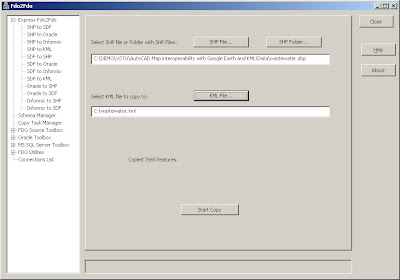

7. Goto C:\Program Files\AutoCAD Map 3D 2010\FDO\bin and create a backup of the providers.xml file in the directory called providers_bkup.xml

8. Right click on providers.xml and open the file with wordpad

9. Copy the following before the tag at the bottom. Click > Save
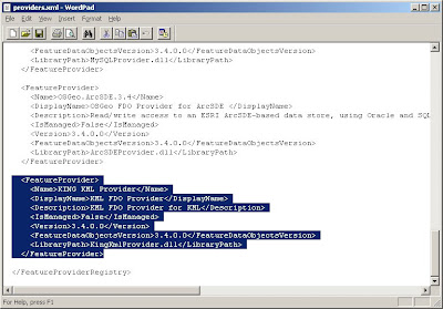

10. If you have AutoCAD Map 3D open, close and reopen the application
11. Open the Display Manager and choose the DATA button and ‘Connect to Data’
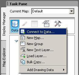


12. Enter C:\wastewater.kml for the file > Click Connect


13. Check on the KMLFDOCLASS and Click > Add to Map

14. Close the Data Connect dialog
15. Edit some of the features using the Check-out and Check-in FDO method

16. After making changes close the drawing and double click on c:\wastewater.kml. You will be able to see your changes in Google Earth.

Tuesday, June 9, 2009

The Great Alaskan Autodesk Roadshow


If you're in Anchorage Alaska on June 24, please stop by and take a look at the new technology available in the Autodesk 2010 products. Select the image to view the agenda, list of speakers and to register.